Kasca
Kasca is a region in the conworld of Akana. It has a longer civilized history than most other regions in the world, stretching at least as far back as the Ngauro civilization of approximately -4000 YP. At times in its history Kasca could be called a nation; at other times, it has been divided between others. It has also been the center of at least one empire.
This article focuses on the state of affairs in Kasca during the classical era, around 200 YP.
Names
| Language | Name | Pronunciation | Source |
|---|---|---|---|
| Ndak Ta | Kasadgad | [ka.sɐd.ɡɐd] | presumably Ng. *kazd-kazd "many rivers" |
| Adāta | Kāxad | [ˈkaː.xad] | ← NT Kasadgad |
| Fáralo | Kazəgad | [ˈka.zə.ɡad] | ← NT Kasadgad |
| Naidda | Kasca | [ˈkas.t̠ʃə] | ← NT Kasadgad |
| Wippwo | Kaš | [ˈkaʃ] | ← Ndd. Kasca |
| Buruya Nzaysa | Kasaga | [ˈkʰa.sa.ɡa] | ← NT Kasadgad |
| Ndok Aisô | Axôkseuhod | [a.ʔɞk.sɛwˈhoʔ] | ← toponym prefix a- + NT Kasadgad |
| Mavakhalan | Koxað | [ˈkɔ.xað] | ← Ad. Kāxad |
| Ayāsthi | Cáġat | [ˈkɑː.ɦɑt] | ← Ad. Kāxad |
| Namɨdu | Kozyad | [ˈkʰʌz.jad] | ← F. Kazəgad |
| Woltu Falla | Kažžad | [ˈkaʒ.ʒɐt] | ← F. Kazəgad |
| Cəssın | Kargan | [ˈkɑɾ.ɡɑɳ] | ← F. Kazəgad |
| Erhadzy | Kálesə | [ˈkɑ.lɛ.sə] | ← Yhát Qáles |
History
Ndak Empire
- Main article: Ndak Empire
Kasadgad had no natural defenses (except the sea), and had thus been invaded and conquered many times. The Ndak were not the earliest recorded inhabitants; those were the Ngauro, who established civilization, including writing, but were divided into squabbling city-states. Archeological excavations of a few small tels and middens around the lower-middle Aiwa, particularly in the area of Buruya, indicate that even the Ngauro were almost certainly preceded by one or more pre-civilized cultures living in small walled towns. Little is known about these people.
The Ndak originally lived along the middle Aiwa. They were briefly ruled by the Ngauro, but soon established a kingdom of their own. They fought several wars with the Ngauro and finally conquered them. Over time the Ngauro language was replaced with Ndak Ta, and indeed the perceived center of the Ndak world shifted to the more populous delta. The Ndak in their turn were conquered (once by hill tribes from the north, twice by nomads from the west), but their edge in population had become secure; they eventually either revolted, or absorbed their conquerors.
After the Ndak expelled the last of the conquerors, they entered a new period of vigor, which culminated in the conquest of the entire Aiwa plain, the littoral, and much of the rugged mountains to the west, from their bases in Kasca and along the Aiwa. The Ndak Empire was the first true empire on Akana, at least in this part of the world. Much of this was the work of one dynasty of emperors; Tsinakan was the third in this line and perhaps the greatest of them all. Tsinakan is the subject of the infamous Tsinakan text, the standard comparison text used among Edastean philologists. His father Terakan also found a lasting place in local legend, though historians pay less attention to him.
Post-Ndak period
The Ndak decline took time. Kasadgad hung on as a political entity for several centuries after having lost control over everything else. It was late in this period, in -1258 YP, that Kasadgad experienced a last gasp of vitality, managing to reconquer both the Huyfárah littoral and most of the Aiwa below Lasomo. Two of these latter-day kings, Sadgukiyat and his son (or maybe nephew) Meyut, were recorded in legend and song. Historians have difficulty piecing together the fragmentary accounts of other kings of this era, and nobody is entirely certain who they all were, nor about the accession dates of these two or any reliable description of their accomplishments. If it weren't for the Faraghin scribes of this era, we may not even have been sure that these two were more than mythical figures.
The final full loss of Ndak vitality is partly due to a natural disaster, although they were clearly already in serious decline. In -1202, Kasadgad was devastated by one of the rare major hurricanes to come ashore along its coast. Complete loss of many of the coastal towns, coupled with massive inland flooding, nailed shut the coffin on Ndak power. They lost control of all of the coast above Miədu and all the Aiwa river above Buruya, and with the resulting social chaos found themselves unable to maintain any overall societal structure. And to top it all off, due to poor maintenance their canal through the Aiwa delta had silted up, blocking navigation of the delta and thus choking off Kasadgad's economic lifeline. The next three to four centuries were spent in a presumed but unrecorded dark age in which many benefits of civilization were simply lost and a sizeable fraction of the people feralized.
Classical period
Culture
- Main article: Culture of Kasca
The culture of Classical-period Kascans is somewhat dysfunctional. Their traditions of close families and colorful celebrations, and their reputations for quick wit and resilient survival are balanced by their outlook of cynicism, apathetic inertia, and slowness to accept change, with the result that most Kascans live in poverty.
Geography
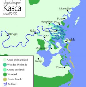
Kasca lies on a broad, flat plain, dominated by a wide, slow river, the Aiwa (also called the Eigə in Fáralo and the Ya in Naidda). The primeval land cover was forest, except for grasses in the rich alluvial plain, and wetlands along the extensive littoral. One Earthly analogue would be the Gangetic plain of northern India. The heartland of Kasca lies around the river delta, but associated settlement has also extended along the river and the littoral since time immemorial.
The Land
The Kascan heartland can be divided into three zones: the fringes of the Aiwa delta; the swampy core of the delta; and nearby associated lands.
The Fringeland
The center of civilization in Ngauro and Ndak times was located primarily of the areas immediately adjacent to the core river delta: the land between and around the branches of the Aiwa in the area where it splits up, plus some of the larger islands connected to the delta. The ground in these areas is relatively stable and provides rich farmland. However, portions of the fringeland are still occasionally prone to floods and periodic reshaping, depending on how well behaved the river is. There are always parts drying out and becoming farmable while other parts are getting eaten away at by the river or becoming soaked until useless for farming, just at a slower rate than happens in the deep delta. Cities have generally been able to hold their own in the fringeland.
The Deep Delta
The central delta zone, meanwhile, has always required a little courage of its residents - but it's certainly not uninhabitable, just problematic. Through most of known history, no single river channel connecting to the sea has been large enough to be navigable, save for when canals have been built or formed. Instead the river branches and branches until at the coast there is mostly just continuous swamp, rather than channels and islands.
Inland from the coast, the delta is characterized by a patchwork of dry-ish islands separated from each other by river corridors. These corridors range from sizeable branches of the river down to broad muddy troughs with little flowing water; but all of them are choked with silt and thick vegetation. Hundreds of the islands are substantial enough and dry enough to be at least partially farmable, and there have always been some islands that are able to host large permanent towns, but frequent shifts of the river channels leave all of the above at risk of floods and crop ruin.
The usefully dry islands form perhaps a third of the core delta's land area, with the rest being swamp and mire. Nevertheless, a substantial population has done its best to live in such conditions for millennia, due in part to the year-round availability of food for comparatively little effort. In the millennia before advanced technology made levees and reliable bridges possible, travel between delta islands was mostly by water and there were few permanent roads.
Nearby areas
The following places have always been closely associated with the Aiwa delta. Traditionally, they and the delta are included together under the name "Kasca":
- The banks along a short stretch of the lower Aiwa before it begins branching, and the alluvial plains around them, collectively called the Vuzëi;
- The peninsula across the bay south of the delta;
- Some of the land north of the delta, extending perhaps up to the city of Momïddo (the exact Kascan border has always been fuzzy here);
- The numerous nearby coastal islands
The agricultural value of these lands is marginally lower than that of the fringeland, although still generally very fertile. But these areas are considered part of Kasca more on a cultural and political basis than on a natural basis, as they tend not to be swampy and don't have to worry much about the behavior of the river.
Cities
Påwe
Påwe is the southernmost and largest of the cities of Classical Kasca, if not by a large margin, and one of only two true city-states in the land, in that it has a stable functioning monarchy controlling not just the city but most of the surrounding region. The monarchy claims descent from the Ndak emperors, though historians have judged this unlikely. Diplomacy, modest economic success, better military strength (it's the only Kascan city with a standing army), and sheer good fortune, have all contributed to the influential position of Påwe within Kasca and its continuing independence from Huyfárah. The king styles himself King of all Kasca, though he does not rule more than a quarter of it - the rest belongs, at least nominally, to Huyfárah. His rule over his own domain is reasonably strong, however, and there is no city of Kasca whose nobility would not listen to him.
Påwe is the economic center of southern Kasca, feeding a large population both from the extensive agricultural land inland of the city and by the thousands of small fishing boats that bring their catches to the wharves of Påwe. More than half the population is directly engaged in these two activities in some way. A great number of basic goods are produced locally as well, so the city is almost self-sufficient except for the more technology-intensive products, especially tools and other metal goods. But its population and good harbor still make it one of the main Kascan ports for Fáralo ships. Though Påwe has yet to fully embrace Fáralo economics on a large scale, on the small scale street markets thrive and burgeon with food and goods.
Names: NT Palwe; of unknown origin. Ndd. Påwe, F. Palge, B.Nz. Palɛ, N.A. Pólôxe, Ad. Palie.
Momuva'e
- Main article: Momuva'e
Momuva'e is Kasca's second-largest, possibly oldest, and most colorful city. It is located on a coastal island that is connected to the Ya river delta.
Names: NT Mos Mumbasi; of unknown origin. Ndd. Momuva'e, F. Muəbaz, B.Nz. Mubasɛ, N.A. Môsp'euseu, Ad. Muphai.
Ñolo
One of the two oldest cities of Kasca, along with Momuva'e, Ñolo was first founded by the ancient Ngauro people. The name derives from Ndak Ta ngaurlau meaning "place of the Ngauro" or perhaps "ancient place". In Classical times there is not much left of the much grander Ndak city, which lies in ruins a mile from the present town, almost wholly obscured by vegetation. Most of Ñolo consists of ramshackle wooden and mud-brick dwellings, while the local noble family's villa and a few of the more important public buildings are constructed of stone blocks unearthed from the ruins.
Ñolo is self-sufficient only in agriculture, and relies on river trade for such finished goods as it can afford. The town is quite poor and not much of interest happens there. Even so, it is the largest settlement of the Vuzëi and in generations past it has been able to muster small armies when the need arose, and retains a strong local identity and pride.
Names: NT Ngaurlau "place of the Ngauro". Ndd. Ñolo, F. Ŋourlo, B.Nz. Ñɔlu, N.A. Ngauloi, Ad. Iūlō, Nolo.
Luyosha
Luyosha is the largest town of the delta proper, and the only one of them to be able to claim much prosperity. It is the last navigable stop on the Ya river, and situated on the largest dry island of the delta. The city arose no earlier than -100 YP; before that time, the river channels were situated differently and the dry island did not exist in its present form. Various noble families of the delta have gradually shifted their homes and business to Luyosha as the city grows. Most of the nobility are delta landholders operating as vassals of higher Fáralo lords, to whom they send a portion of the tithes they collect from their lands. The city itself is not controlled by any particular ruler or ruling body but instead by an ever-shifting set of independent arrangements between noblemen, which leads to frequent conflicts over civil matters.
Luyosha feeds itself much like the rest of the delta does, relying on agriculture supplemented by fowl and whatever wildlife people can catch on their own, but there is also a modest amount of organized river fishing. The dry island is large enough to afford Luyosha the luxury of keeping flocks of sheep for their meat. The city trades upriver and with other towns for most finished goods, but there is a strong local ceramics industry and high-quality pottery from Luyosha is sold as far upriver as Nae'oloda and sometimes even in Ussor.
Names: Ndd. Luyosha; of unknown origin. F. Luyoš, B.Nz. Luyɔsa, Ad./N.A. Loisa.
Nïddola
The city of Nïddola is located on one of the larger among Kasca's numerous coastal islands, and thus relies more heavily on trade than do other towns, needing to import grain in addition to finished goods. Though still Kascan at heart, the town (along with several others in the north) is in the process of being absorbed into the empire of Huyfárah: market economics and Etúgə are increasingly the order of the day, and the local dialect of the Naidda language has is being replaced by the more prestigious Fáralo in public discourse, although Naidda remains the first language for a majority and is still widely spoken at home and on the street. Politically the transition is already complete - it is just another city of Huyfárah.
The people of Nïddola are a more diverse lot than can typically be found in other Kascan cities. In addition to the bilingual and bi-ethnic nature of the town, it represents a cross-section of the populations of Kasca and Huyfárah, including all the major minority groups present in both lands. This leads to a more cosmopolitan environment than is typical of elsewhere in Kasca, and stems firstly from its position (both physical and cultural) as a gateway between two lands and secondly from its greater reliance on sea trade.
Names: Ndd. Nïddola; of unknown origin. Ad./F. Nirola, B.Nz. Nə’ola.
Buruya
- Main article: Buruya
Buruya is a city-state and major trading center on the lower-middle Ya. Buruya has been politically independent of the rest of Kasca for centuries, but still identifies with it culturally. The city is the sole major connection point between two economic spheres - Huyfárah and the Ya river trade - which has fueled steady economic growth over the last century.
Names: Ndd. Buruya, from Me. buru "stronghold" + -ya (honorific). F./B.Nz. Buruya, N.A. Buxói, Ad. Buruia, Buroi.


