Peilaš
Jump to navigation
Jump to search
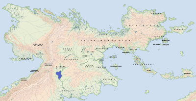
Peilaš is a continent in the world of Akana, with its mainland's northern- and southernmost reaches at approx. 60°N and 25°S and its western- and eastern- at approx. 92°W and 28°E. The continent is centered on a large cordillera, which runs from its eastern tip bowing to the south roughly east-northeast to 25°, where it turns north and grows broader and taller until 50°N, from where it runs east narrowing to the eastern end of the continent. It has expanses of lower land as a large peninsula in the far east, to either side of the mountains in the middle of the cordillera, and another, much larger one extending south from the east-northeast-going mountains.
Names
| Language | Name | Pronunciation | Source |
|---|---|---|---|
| Fáralo | (lu) Peilaš | [lu ˈpe.laʃ] | "(the) large-land" |
| Naidda | Pelasha | [pe.la.ʃə] | ← F. Peilaš (borrowed) |
| Wippwo | Lobeilaš | [lɔ'be.laʃ] | ← Ndd. L-Pelasha |
| Imperial Adāta | Laspē | [ˈlas.peː] | ← F. Peilaš (calque) |
| Namɨdu | Pyołas | [ˈpʰjɔ.ʟas] | ← F. Peilaš |
| Woltu Falla | Pelaš | [ˈpɛ.laʃ] | ← F. Peilaš |
| Cəssın | Piläş | [ˈpi.læɕ] | ← F. Peilaš |
| Mavakhalan | lapê | [ˈla.pe] | ← Ad. Laspē |
| Ayāsthi | làhpē | [ˈlɑh.pɛː] | ← Ad. Laspē |
| Aθáta | Laspé | [lasˈpe] | ← Ad. Laspē |
| Æðadĕ | Læspe | [ˈlæs.pe] | ← Ad. Laspē |
| E'át | Lasplá | [ləsˈpla] | ← Aθ. Laspé |
| Yād | Lespē | [ˈlɛs.peː] | ← Æð. Læspe |
| Zhaj | Rısype | [ˈɾɪ.sʉ.pe] | ← Yād Lespē |
| Yēt | Lĭspī | [ˈlis.pʰiːw] | ← Yād Lespē |
| Erhadzy | Efeí | [ɛ.ɸɛˈi] | ← unknown, "the West" |

